
High tide flood warning issued for Bangkok and seven provinces
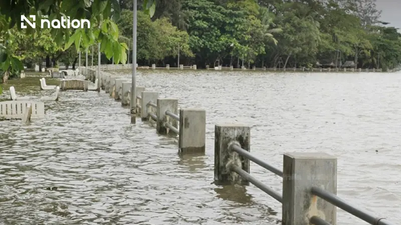


River levels could rise about 0.10–0.30 metres above critical levels, threatening low-lying communities and three major roads.
- A high tide flood warning is in effect for Bangkok and seven provinces from November 9 to 14, 2026.
- The warning is due to strong easterly winds pushing seawater into the Gulf of Thailand, causing water levels in four major rivers to rise above critical thresholds.
- Areas at high risk of flooding include low-lying riverside communities, areas outside flood barriers, and major roads like Sukhumvit Road and Rama II Road.
- Residents in at-risk areas are urged to move valuables to higher ground and monitor official water-level alerts.
The Office of the National Water Resources (ONWR) has issued a high tide warning for November 9 to 14, 2026.
Relevant agencies and residents in low-lying riverside areas, including communities outside flood barriers, have been urged to prepare for water levels that could exceed critical thresholds and flood homes and major transport routes.
Causes of the high tides
According to a weather and hydrological report from the Royal Thai Navy’s Hydrographic Department, easterly winds over Thailand and the Gulf of Thailand are beginning to strengthen.
These winds are a key factor behind the high tides, continually pushing seawater towards the mouth of the gulf and raising sea levels above normal.
The effects extend to major rivers connected to the sea, where water levels are forecast to reach about 0.10–0.30 metres above critical thresholds.
Low-lying and riverside areas could be affected suddenly.
Four rivers at risk in Bangkok and seven provinces
The high tides will directly affect four major rivers that flow into the Gulf of Thailand:
- Bang Pakong River
- Chao Phraya River
- Tha Chin River
- Mae Klong River
The ONWR has urged relevant agencies in Bangkok and seven provinces to monitor conditions closely and prepare response plans:
- Chachoengsao
- Samut Prakan
- Bangkok
- Nonthaburi
- Pathum Thani
- Samut Sakhon
- Nakhon Pathom
- Samut Songkhram
Communities and roads requiring particular caution
A risk assessment identifies three main categories of area where rising water could cause flooding:
- Riverside and low-lying communities: Communities along the Bang Pakong, Chao Phraya, Tha Chin and Mae Klong rivers.
- Areas outside flood barriers: Communities beyond flood barriers or in areas without permanent flood protection.
- Travel routes and major roads: Standing water could affect road surfaces on Sukhumvit Road, Suksawat Road and Rama II Road
How residents should prepare
- Residents in communities outside flood barriers and low-lying riverside areas should promptly move belongings, electrical appliances and valuables to higher ground.
- Check sockets and wiring at home. If flooding begins, immediately cut off the electricity supply in areas at risk for safety.
- Road users travelling on Sukhumvit Road, Suksawat Road and Rama II Road should plan their journeys in advance and avoid periods of high tide.
- Regularly monitor water-level alerts from the ONWR, the Royal Thai Navy’s Hydrographic Department and government agencies in the area.
