
Call of the Sahara


Play
Almost as big as the USA, Africa's sandpit throws up psychedelic rocks, swallows the world's biggest art gallery, and even bakes bread
The great Sahara Desert had been on my bucket list for a long time.
Almost as big as the USA, its ocean of sand stretches from the Atlantic coast to the Red Sea, submerging a vast swathe of Morocco, Western Sahara, Mauritania, Senegal, Mali, Algeria, Niger, Tunisia, Libya, Chad, Egypt and Sudan.
At over 9.4 million sq km, the Sahara is by far the largest desert – as the word is popularly used – on Earth.
Geographers, however, define a desert as any place with a total annual precipitation (rain, snow, etc) of less than 250mm. By this definition, the continent of Antarctica, contrary to most people’s belief, is the largest desert, followed closely by the Arctic, with the Sahara a lowly third.
I embarked on my desert odyssey with my wife and a friend, and after a first night in the Tunisian capital, Tunis, we crossed into Algeria for a week spent visiting its cities and Roman ruins along the Mediterranean coast.
From Tlemcen near the Moroccan border, our four-wheel-drive headed south towards Taghit about 680km away. Speeding along the two-lane highway at 140kph, our driver-cum-guide Badjou soon arived at the border marker for the Sahara.
Algeria is Africa’s fourth largest country and 80 per cent of its 2.38 million sqkm is sparsely populated desert.
Like most people, my idea of the Sahara was an endless expanse of sand dunes traversed here and there by camel trains. The reality is that the desert is principally rocky – a crumbling ancient landscape of stone plateaus (hamada), gravel plains (reg), dry valley and salt flats (shatt). Sandy seas (erg) of dunes make up less than 20 per cent of the total area.
So when the oasis town of Taghit came into view at the foot of magnificent golden sand dunes in the late afternoon, we were truly impressed. We spent the following day exploring a nearby valley, the old ksar (an abandoned beehive-like communal dwelling of red mud houses) and the town itself. We had our first encounter with exquisite rock carvings of animals, a precursor to the many we would see on the trip.
Moving on towards Timimoun, sand-dune waves reared up on both sides of the road. Their curves and shades intertwined in a mesh of colours more subtle and beautiful than any painting I have ever seen. The dunes are part of the Grand Erg Occidental, a belt of sand seas that extends northeast from Taghit.
Ghardaia, our next stop, is 630km north-east of Timimoun. Nestled here in the M’Zab valley are five villages inhabited principally by the Mozabite tribe, a Berber people who once lived throughout southern Algeria.
Our guide Badjou is a Mozabite. Their women are the most conservative in Algeria, covered from head to toe in white whenever they venture out, leaving only a small triangular opening for one eye to see the way. Even at home, they have to cover up to avoid being seen by any man other than their husbands.
We then flew on to Tamanrasset, 1,375km south of Ghardaia, and were again surrounded by rocks. Tamanrasset is deep in the heart of the Sahara and close to the Niger border.
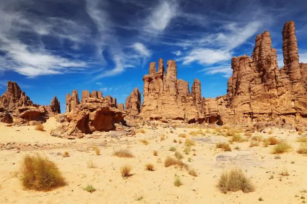
Following the Assekrem Circuit, we spent three days exploring the strange rock formations. Chief among them is Assekrem, a mountain that erupts up from the desert to a 3,000m summit.
Assekrem is home to the Hermitage of Charles de Foucauld, which is still inhabited by two French Christian monks, seeking the insights once gained by their desert-hermit forefathers.
At our lodge on the mountainside, we rise early and watch the rising sun give birth to a ragged jaw of rocky peaks spanning the horizon. I spent a solid hour photographing the magical play of colours, light and shadow.
From Tamanrasset, we took another flight to Djanet about 700km away. Here, we were close to the Libyan border and at the gateway to Tassili n’Ajjer National Park. This 114,000sq km territory is dubbed the largest open-air art gallery in the world on account of the concentration of cave paintings and engravings in the region.
We spent five days exploring a small part of Tadrart Acacus, which lies within the National Park. Our guide, a 34-year-old Tuareg by the name of Ali, was a jovial character who spoke good English. On the other hand, Hamdani, our Tuareg driver-cum-cook, spoke no language we could understand.
Other than leading us to the site of ancient rock engravings, Ali also pitched our tents and prepared tea for us after every meal.
Hamdani had a few tricks up his sleeve too, showing us how to bake bread by burying it in sand with a fire over it.
Both these desert dwellers were expert guides to our voyage through the sandy seas, unveiling some of the mysteries that lie among its searing waves.
This landscape, deadly to the unwary and unprepared, is also alive with mysterious beauty.
