
Forest loss may amplify Nan flood risk, studies find
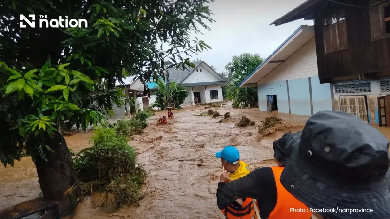


Extreme rain triggered Nan’s floods, while decades of forest-to-farmland conversion may have increased erosion and run-off risks
- While extreme rainfall was the direct trigger for the Nan floods, long-term forest conversion to cropland is believed to have amplified the disaster by increasing vulnerability to rapid run-off and erosion.
- A satellite study found that between 2001 and 2016, Nan lost over 412,000 rai of forest, with 92% of this land converted to agriculture, primarily for maize cultivation.
- Converting mountain forests to farmland worsens flooding because exposed soil increases surface water run-off, whereas forests help slow water and maintain soil infiltration.
- A local watershed study concluded that cropland accounted for nearly 88% of modeled soil erosion, supporting the theory that upland farming increases flood risks.
Extreme rainfall was the immediate trigger for the latest deadly flooding in Nan, but long-term forest conversion may have made parts of the province more vulnerable to rapid run-off, erosion and sediment movement.
As of 4pm on Wednesday (August 19), flooding in Pua district had affected seven subdistricts, 60 villages and about 8,000 households, leaving more than 16,000 people in difficulty. Two deaths had been reported.
Although water levels in parts of Pua began falling, the flood mass was moving downstream towards Tha Wang Pha and communities along the Nan River. Vulnerable residents were evacuated, while roads were closed because of flooding, landslides and fallen electricity poles.
The Thai Meteorological Department attributed the severe weather to a monsoon trough across upper northern Thailand, a strong low-pressure area near Hainan and a relatively strong southwesterly monsoon. It warned that heavy and accumulated rain could cause flash floods, forest run-off and overflowing waterways.
What the forest evidence shows
Social-media photographs of exposed hillsides have renewed claims that forest clearance caused the flooding. However, photographs alone cannot confirm when vegetation was removed, whether the land was being cultivated or how much its condition contributed to this particular disaster.
Official statistics show that Nan retained 4.636 million rai of forest in 2024, or 61.16% of the province. That was down from 4.659 million rai, or 61.45%, in 2016—a net decline of about 22,230 rai.
The figures do not indicate a sudden recent collapse in province-wide forest cover. They can, however, conceal local clearing, degradation and regrowth occurring in different areas.
A high-resolution satellite study published in Global Change Biology found that Nan lost 66,072 hectares, or about 412,950 rai, of forest between 2001 and 2016. Researchers found that 92% of the lost forest had been converted to cropland by 2017, mainly maize.

Why land conversion may amplify flooding
Forests cannot prevent every flood. Once rainfall overwhelms saturated soil, streams and rivers, severe flooding can occur even in well-forested catchments.

However, converting mountain forest to annual crops can alter how water and soil move downhill. Tree roots, leaf litter and forest soil help slow water and maintain infiltration, while exposed or compacted farmland can produce faster surface run-off.
A seven-year watershed study in Nan found that cropland accounted for 87.52% of the modelled soil erosion among the land-use categories studied. Areas with dense cultivation also generated high sediment yields.
These findings support the conclusion that upland farming can increase erosion and affect watershed behaviour. They do not prove how much forest conversion contributed to the August 2026 flood.
Nan’s natural geography is another major factor. A flash-flood susceptibility study identified Pua, Bo Kluea, Song Khwae and Mueang Nan among the most vulnerable areas because of steep slopes and high rainfall.
A province repeatedly hit by floods
Nan’s flood history shows that the latest disaster is not an isolated event.

The Nan River reached about 8.42 metres during the major flood of 2006. The entire province was declared a disaster zone in 2011, while six districts were declared disaster zones and one death was recorded in 2016.
In 2018, more than 1,000 households across seven districts were flooded when the Nan River and its tributaries overflowed.
The 2024 disaster was even larger. Provincial authorities recorded 32,434 affected households, 134,472 people and three deaths. The river reached 8.72 metres, exceeding the 2006 benchmark, according to Nan’s Public Relations Office.
Flooding associated with Tropical Storm Wipha struck again in 2025, affecting 33,681 households and damaging about 141,795 rai of farmland, according to the Ministry of Labour.
What can be concluded
The available evidence supports a cautious conclusion: extreme rain triggered the latest disaster, while decades of forest conversion and hillside cultivation may have amplified run-off, erosion and sediment risks in some catchments.
Determining their exact contribution would require an event-specific investigation using rainfall, soil-moisture, river-discharge, sediment and current land-cover data.
In the longer term, reducing Nan’s vulnerability will require the protection of headwater forest, restoration of streamside vegetation, tighter management of cultivation on erosion-prone slopes and improved soil-conservation practices.
Source: seven-year watershed study in Nan , high-resolution satellite study published in Global Change Biology , flash-flood susceptibility study
