
Heavy rain raises Mekong levels and flood risk in Northeast Thailand
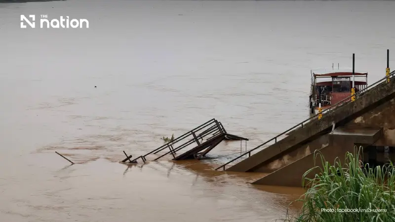


Water agencies warn that the Mekong may rise by 1.0–1.5 metres, with alerts for flash floods, landslides and rough seas across several regions.
- Persistent heavy rain in Northeast Thailand, Myanmar, and Laos is causing water levels in the Mekong River to rise, increasing the risk of flooding.
- Authorities forecast the Mekong will rise by 1.0 to 1.5 meters between August 8 and 12, prompting alerts for flash floods and runoff.
- Several northeastern provinces along the Mekong are on high alert, particularly low-lying areas in Loei, Bueng Kan, Nong Khai, Nakhon Phanom, Mukdahan, and Ubon Ratchathani.
The Hydro-Informatics Institute (HII) reported on Sunday (August 9, 2026) that its monitoring of the Northeast showed persistent heavy rain across the region, Myanmar and Lao PDR, with rainfall continuing to accumulate.
The rain had caused waterlogging and raised water levels in the Northeast, particularly along the Mekong River.
Weather radar at 11.15am showed continuing rain across the area.
Heavy rain was forecast to persist in the Northeast from August 9 to 11.
The situation required close monitoring, particularly in low-lying areas along the Mekong in Loei, Bueng Kan, Nong Khai, Nakhon Phanom, Mukdahan and Ubon Ratchathani.
HII warned of areas at risk of flash floods and run-off between August 9 and 11.
It also identified areas requiring special monitoring for 48 hours.
The Office of the National Water Resources (ONWR), meanwhile, issued an alert for rising Mekong levels from August 8 to 12.
Its monitoring found heavy rain in Myanmar, Lao PDR, northern Thailand and northeastern Thailand.

The Mekong was forecast to rise by 1.0–1.5 metres during that period, from Chiang Saen district in Chiang Rai to Khong Chiam district in Ubon Ratchathani.
Relevant agencies and provinces along the Mekong were asked to publicise warnings, monitor rising river levels and urge caution over river travel and activities.
The alert covered eight Mekong-side provinces, particularly low-lying riverside areas in Nong Khai, Bueng Kan and Nakhon Phanom.
The Department of Disaster Prevention and Mitigation (DDPM) issued the following disaster warnings for Sunday (August 9, 2026):
Flash floods, run-off and short-term waterlogging: Mae Hong Son, Chiang Mai, Chiang Rai, Lamphun, Lampang, Phayao, Nan, Uttaradit, Phetchabun, Loei, Nong Khai, Bueng Kan, Sakon Nakhon, Nakhon Phanom, Chanthaburi and Trat.
River overflows and waterlogging: Phayao and Nan.
Landslides: Mae Hong Son, Chiang Rai and Nan.
Rising Mekong levels: Chiang Rai, Loei, Nong Khai, Bueng Kan, Nakhon Phanom, Mukdahan and Ubon Ratchathani.
Strong winds and waves: Chonburi, Rayong, Chanthaburi, Trat, Ranong, Phang Nga and Phuket.

Latest flood update following heavy rain, Saturday (August 8, 2026)
Chiang Mai
Persistent rain caused the Huai Mae Wa watercourse to overflow, flooding areas in Phrao, Wiang Haeng, Chiang Dao and Mae Ai districts.
Seven subdistricts and 11 villages were affected, involving 171 households.
That morning, heavy rain in Mae Taeng district also sent run-off into homes and farmland, while a landslide blocked a road.
The affected area covered three subdistricts: Ban Chang, Kued Chang and Pa Pae.
The situation had since eased.
Chiang Rai
Continuous rain around the old Pa Ngae municipal office inundated the road linking Pa Daet and Phan districts.
Local agencies assisted residents and installed warning signs at risk points.
The province planned to deploy machinery on Sunday (August 9, 2026) to clear drainage routes and dredge additional drains.
Lampang
Persistent heavy rain in Chae Hom district overwhelmed drainage and sent water into homes in Moo 5 of Mae Suk subdistrict.
Water levels had since fallen and conditions had returned to normal.
Mae Hong Son
Persistent rain caused run-off and flooding in Mueang Mae Hong Son and Pai districts, affecting six subdistricts and 12 villages.
Fast-flowing water further damaged the structure of Su Tong Pae Bridge in Kung Mai Sak village, Pang Mu subdistrict.
Monks and novices from Wat Phu Samana Ram used the bridge when travelling on alms rounds.
The bridge, which was already under repair, became impassable after sustaining further damage.
Surrounding rice fields were also flooded and damaged.
Water levels had since fallen.
Lampang
Continuous rain caused waterlogging in Mae Suk subdistrict of Chae Hom district, affecting one household.
The situation had since eased.
Nan
Conditions in several areas had largely returned to normal, with water levels in most flooded areas and tributaries falling.
Relevant agencies were accelerating restoration and clean-up work and surveying the damage to consider assistance in line with regulations.
