
Easy-to-read Flood Marks help communities prepare for floods with three days’ warning
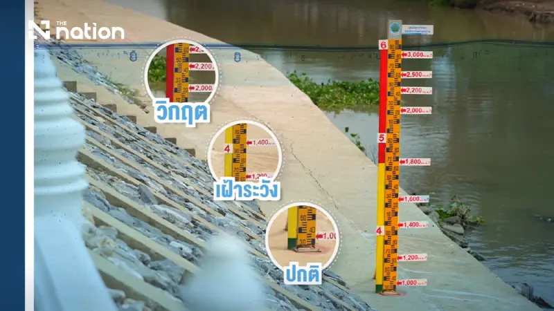


The Royal Irrigation Department is expanding its installation of Flood Marks, or “water watch posts”, across the Chao Phraya and Tha Chin river basins to turn complex hydrological data into simple colour-coded warnings for riverside communities.
The system can help residents anticipate rising water levels two to three days in advance, giving them time to move belongings, protect property and prepare for possible flooding.
During the rainy season and periods of high water flow, riverside residents principally want to know whether their homes will flood, when they should move their possessions and how much preparation time remains.
However, official information is often presented as hydrological figures, such as discharge rates of hundreds or thousands of cubic metres per second, which can be difficult for the public to interpret and may not directly answer those practical questions.
In the past, many residents relied on their memory of previous flood levels. Over time, however, those recollections could become inaccurate or be forgotten, leaving communities without a clear benchmark for deciding when to act.
This problem led to the development of the Flood Mark system.


Turning technical data into visible warnings
Thanes Sombun, director of the Royal Irrigation Department’s Office of Water Management and Hydrology, said Flood Marks converted complicated hydrological information into clear warning signs that could be understood immediately.
A Flood Mark consists of a water-level gauge, or staff gauge, installed in a river or at a high-risk location within a community.
It allows officials and residents to monitor river levels continuously and serves as the final point in a communication chain carrying information from water-monitoring stations and operational centres directly into communities.
The system uses historical upstream data to forecast downstream water levels. When water is discharged through the Chao Phraya Dam at different rates, officials can calculate how much the level in riverside communities is likely to rise — for example, by 20 centimetres, 50 centimetres or one metre.

Installing a Flood Mark at a familiar community landmark allows residents to see what the forecast means for their own area and anticipate conditions two to three days before water flowing from upstream arrives.
“This method is easier to remember and record,” Thanes said.
“In the past, riverside residents relied on their memories of previous flood levels, which could be forgotten or inaccurate. As a result, there was no definite water-level benchmark for preparing for a disaster.”
First installed in Ayutthaya lowlands
The Royal Irrigation Department began installing Flood Marks in 2023 in low-lying areas affected by water released downstream of the Chao Phraya Dam.
The initial locations included Bang Ban and Sena districts in Phra Nakhon Si Ayutthaya province.
The posts help residents understand how increases in water discharged from the dam and flowing through Chai Nat, Sing Buri and Ang Thong will affect levels in their communities.

Requests have also been made to install the system at other important locations, including Wat Kasattrathirat Worawihan, to monitor water levels in historic communities and the city of Ayutthaya.
Initial feedback showed that local people were interested in the system and had used its information to prepare for flooding in time.
Flood Mark readings are linked with data from water-monitoring stations, including C.2 and C.29B, and with the website of the Central Region Irrigation Hydrology Centre.
The connections provide transparent and verifiable confirmation of discharge rates from the Chao Phraya Dam.
CCTV offers real-time view of water levels
Closed-circuit television cameras have also been installed to provide real-time images of water levels.
The live pictures allow residents to see actual conditions without having to interpret technical figures, helping them decide more quickly whether to evacuate or protect their property.
The system can reduce possible losses while encouraging communities to participate more actively in local flood-warning arrangements.
Following its initial success in the Chao Phraya basin, the Flood Mark scheme was expanded along the Tha Chin River, from downstream of the Pho Phraya sluice gate in Suphan Buri to Nakhon Pathom province.
The covered areas include Lam Phaya Subdistrict Municipality, Bang Len Town Municipality, Nakhon Chai Si Subdistrict Municipality, Khun Kaeo Subdistrict Municipality, Bang Kradi Subdistrict Municipality and Sam Phran Town Municipality.
Flood Mark information in the Tha Chin basin is also used to support agricultural planning and the management of local economic activities.
The Royal Irrigation Department plans to expand the system beyond central Thailand to other major river basins, including the Mun River basin in Ubon Ratchathani.
The expansion would allow communities in the Northeast to understand and monitor local warning levels in the same way.

Green, yellow and red bands explain the risk
To eliminate difficulties in interpreting hydrological figures, the Flood Marks use a universally recognisable colour-band warning system.
Green indicates that the water level is normal and the river can still accommodate the flow, allowing residents to continue their usual activities.
Yellow means the water is beginning to rise to a level requiring close monitoring. Communities should prepare and remain alert.
Red indicates that the water has reached a risk level or is close to overflowing the riverbank. Residents must move belongings to higher ground and immediately follow their emergency-response plans.
“The green, yellow and red bands allow every group in a community to use the same language when communicating about a disaster,” Thanes said.
“They reduce confusion and allow decisions on evacuation or property protection to be made more quickly.”
Communities and local authorities support installations
The Flood Mark project relies on close cooperation among government agencies, local authorities and residents.
Some residents provide space along riverbanks or in front of their homes for the posts, while subdistrict and district municipalities support the construction and installation costs.
The Royal Irrigation Department, through its Office of Water Management and Hydrology and provincial irrigation projects, provides technical support.
Its responsibilities include installing the water-level gauges, calculating warning thresholds and determining the positions of the colour bands.
The process begins when a local administrative organisation or provincial authority submits a request to the relevant provincial irrigation project.
The request is then forwarded to the Royal Irrigation Department, which sends engineers and hydrologists to survey the area, consult residents and analyse actual historical flood data.
The Flood Mark is then installed systematically at a location recognised as a community landmark.
“Flood Marks cannot stop flooding, but they ensure that communities do not have to confront it without information,” Thanes said.
“Converting technical figures into easily visible colour symbols creates a shared understanding among government agencies, local authorities and residents.
“It strengthens confidence, reduces losses of life and property, and helps riverside communities build the capacity to respond to floods effectively and sustainably.”
Communities seeking a Flood Mark can submit a request through their local administrative organisation. The application will be passed to the provincial irrigation project and subsequently to the regional irrigation hydrology centre for installation.
