
Satellite images reveal widespread flooding across 14 provinces
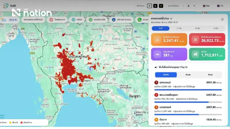


GISTDA satellite data shows about 131,594 hectares of flooding across 14 provinces, while new platforms offer round-the-clock monitoring and three-day flood-risk forecasts.
The Geo-Informatics and Space Technology Development Agency (GISTDA) has released satellite data showing around 131,594 hectares (822,464 rai) of flooded land across parts of 14 provinces.
The data, captured by the Radarsat-2 satellite on Saturday (September 26), identified inundated areas in Phichit, Nakhon Sawan, Suphan Buri, Sukhothai, Ayutthaya, Phitsanulok, Kamphaeng Phet, Chai Nat, Lop Buri, Saraburi, Ang Thong, Phetchabun, Uthai Thani and Sing Buri.
GISTDA has forwarded the information to key agencies responsible for flood management to support planning, monitoring and continued assessment of conditions in affected areas.
Members of the public can also follow updated flood conditions through GISTDA’s disaster-monitoring platform.
The “Check Nam” application, available on both iOS and Android, provides round-the-clock information on the movement of floodwater, hazard-warning points and conditions in individual areas.

Life Dee and Check Nam launch three-day flood-risk forecasts
GISTDA’s Life Dee platform has also integrated data from Check Nam to help the public monitor flood risks and prepare for possible inundation.
The service provides forecasts of areas at risk of flooding 24 hours, one day, two days and three days in advance.
It can also indicate whether a user’s home is located within a risk area, helping residents and relevant agencies prepare, plan their response and provide assistance more quickly.
Information relating to vulnerable groups is still being developed and compiled in cooperation with relevant agencies.

For those who wish to help our fellow citizens suffering and affected by the floods, you can make a donation through the following accounts:
Nation Foundation
Bank of Ayudhya (Krungsri): Account No. 333-0-01399-6
Kasikorn Bank: Account No. 192-3-59782-0
"We will get through this crisis together."
