
RID Assures Bangkok Safe as River Discharges Remain Under Control
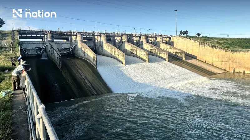


Royal Irrigation Department confirms water releases from Chao Phraya and Pa Sak dams remain within safe thresholds for Bangkok’s flood barriers
- The Royal Irrigation Department (RID) confirms that water releases from the Chao Phraya and Pa Sak dams are being managed at levels that do not threaten Bangkok's flood barriers.
- Water flow measured upstream of Bangkok is approximately 2,382 cubic meters per second, which is well below the city's flood defense safety threshold of 3,600 cubic meters per second.
- Authorities are actively managing water by using canals, pumping stations, and sluice gates to divert flows and accelerate drainage into the Gulf of Thailand.
- Despite controlled river levels, the primary flood risk for Bangkok in the coming days is from intense, localized rainfall that can overwhelm the city's internal drainage networks.
The Royal Irrigation Department confirms water releases from Chao Phraya and Pa Sak dams remain within safe thresholds for Bangkok’s flood barriers.
Thailand’s Royal Irrigation Department (RID) has confirmed that water discharge rates from both the Chao Phraya Dam and the Pa Sak Jolasid Dam remain manageable, with flow rates entering Greater Bangkok staying well within the safety limits of the capital’s flood barriers.
Authorities are accelerating drainage operations across canal networks and managing water movement to free up storage capacity for anticipated rainfall and minimise disruption to local communities.
The RID is monitoring conditions across the Chao Phraya and Pa Sak river basins while actively regulating irrigation channels according to regional capacity.
The department reiterated that current discharge levels pose no immediate threat to Bangkok’s flood protection embankments, even as canal systems are cleared to accommodate incoming storms.
Current Water Levels and Dam Operations
As of 3 October 2026, water flow at station C.2 in Mueang District, Nakhon Sawan Province, has begun to decline following the passage of peak northern runoff.
Downstream, the Chao Phraya Dam is maintaining a discharge rate of approximately 2,500 cubic metres per second. The RID continues to monitor tributary inflows and localised rainfall to optimise discharge timing.
At the Pa Sak Jolasid Dam, where storage levels remain elevated, water is being released in gradual increments to expand storage capacity while aligning flow rates with downstream absorption levels along the Pa Sak and Chao Phraya rivers.
Combined runoff from both dams merges before reaching station C.29B in Sam Khok District, Pathum Thani Province—the final measuring station upstream of Bangkok.
Flow rates at C.29B recorded an average of 2,382 cubic metres per second, remaining below Bangkok's flood defence safety threshold of 3,600 cubic metres per second.
Regional Drainage Strategy Across Greater Bangkok
To delay peak flows and expand holding capacity, the RID is utilising canals and water control structures to divert and retard water volumes before they reach the capital.
Across Bangkok and neighbouring provinces, the RID is working in tandem with the Bangkok Metropolitan Administration (BMA) and local authorities to manage drainage through coastal channels, sluice gates, and pumping stations:
Upper Sector: Semi-permanent pumping stations at Pak Khlong Rangsit are intercepting and diverting northern flows before entering Bangkok.
Central Sector: Flow management is directed through Khlong Saen Saep, Khlong Prawet Buri Rom, and interconnected pumping networks.
Lower Sector: Coastal pumping facilities—including Chonlahan Pichit, Suvarnabhumi, and the Royal-initiated Khlong Lat Pho floodgate—are accelerating discharge into the Gulf of Thailand, synchronised with sea tide cycles.

Weather Outlook and Urban Vulnerabilities
Authorities caution that the primary risk to Greater Bangkok over the coming days remains intense localised downpours. Unlike river runoff from northern reservoirs, urban rain drains directly into municipal drainage networks, creating risks for low-lying zones, drainage bottlenecks, and riverside settlements.
According to meteorological forecasts:
5–7 October: Rainfall is expected to increase in select areas.
8–9 October: Precipitation is forecast to ease temporarily.
11–14 October: A renewed wave of heavy rainfall is anticipated across the Central Region, extending southwards from Nakhon Sawan.
Taking advantage of the current ebb in northern runoff, the RID is expediting canal drainage to maximise storage capacity before the next rain cycle.
Residents in Greater Bangkok are advised to follow official weather bulletins and river level monitoring closely.
Nationwide Flood Context
The localised water management measures come as Thailand contends with widespread seasonal flooding.
According to the Department of Disaster Prevention and Mitigation (DDPM), flooding remains active across 30 provinces, affecting more than 1.1 million households and over 3.3 million people across 191 districts.
The disaster—triggered by heavy seasonal monsoon rains combined with northern runoff—has impacted over 1,200 sub-districts nationwide, with relief operations underway across northern, central, and northeastern regions.
