
Heavy rain hits southern Thailand as western reservoirs reach 96%
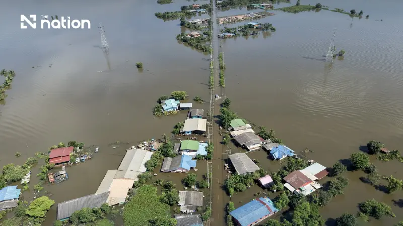


Thailand reports 137mm of rain in Yala and 126mm in Phetchaburi. Western reservoirs are 96% full as authorities accelerate drainage in the Bang Pakong basin.
- Southern Thailand has been hit by heavy rain, with Yala province recording 137mm.
- Reservoirs in the country's western region have reached 96% of their total storage capacity.
- Further heavy rainfall is forecast for the south, while conditions are expected to improve in upper Thailand.
Heavy rain affected southern and western Thailand on Sunday (October 11), with Yala recording 137 millimetres (mm) and Phetchaburi 126mm, while reservoirs in the western region stood at 96% of capacity.
The Office of the National Water Resources (ONWR) reported the figures at 7am and was coordinating efforts to accelerate drainage in the Bang Pakong River basin in eastern Thailand, where accumulated floodwater remained a concern.
Upper Thailand continued to experience thundershowers and isolated heavy to very heavy rain, while southern provinces faced persistent rainfall.

Yala and Phetchaburi record highest rainfall
The ONWR identified the provinces with the highest rainfall in each of Thailand's six regions as follows:
- North: Nakhon Sawan, 98mm
- Northeast: Surin, 74mm
- Central: Lop Buri, 20mm
- East: Chanthaburi, 38mm
- West: Phetchaburi, 126mm
- South: Yala, 137mm
Rain expected to ease in upper Thailand from October 12
Rainfall is forecast to ease across upper Thailand between October 12 and 16 as a high-pressure system from China extends over the region.
Rain is expected to persist in southern Thailand, however, with isolated heavy to very heavy downpours possible.
Western reservoirs reach 96% of storage capacity
Thailand's reservoirs collectively contained 65,931 million cubic metres of water, representing 82% of their total storage capacity, according to the ONWR's October 11 report.
Of this amount, usable water reserves stood at 41,822 million cubic metres, equivalent to 74% of usable storage capacity.
The regional breakdown was as follows:
- North: 20,904 million cubic metres, or 76% of capacity
- Northeast: 8,363 million cubic metres, or 70%
- Central: 1,326 million cubic metres, or 71%
- East: 2,729 million cubic metres, or 88%
- West: 27,246 million cubic metres, or 96%
- South: 5,363 million cubic metres, or 68%
The high storage levels in western and eastern Thailand underline the importance of carefully managing reservoir operations, particularly if further heavy rainfall occurs.
However, reservoir levels alone do not indicate flood risk in a particular area, which also depends on rainfall, river flows and drainage capacity.

Chao Phraya monitoring stations recorded levels below riverbanks on October 1
Separate monitoring data from the Chao Phraya River basin, recorded at 6am on October 1, showed that water levels were below the riverbanks at three key stations in Nakhon Sawan province.
The readings were as follows:
- Station P.17, Banphot Phisai district: Water level of 34.88 metres above mean sea level, or 3.37 metres below the riverbank, with a declining trend.
- Station N.67, Chum Saeng district: Water level of 25.54 metres above mean sea level, or 2.67 metres below the riverbank, also showing a declining trend.
- Station C.2, Mueang Nakhon Sawan district: River discharge of 1,885 cubic metres per second, with a water level of 22.42 metres above mean sea level, or 3.28 metres below the riverbank.
The figures also indicated that Chao Phraya Dam was releasing water at 2,100 cubic metres per second. Water levels upstream and downstream of the dam stood at 15.68 metres and 14.98 metres above mean sea level, respectively.
These measurements were taken on October 1, not October 11, and should not be used to assess current conditions without updated data.

ONWR accelerates Bang Pakong drainage with 10 additional units
Despite efficient discharge around Bang Pakong Dam, substantial volumes of floodwater remain in the wider river basin.
Floodwater is flowing into the basin from areas downstream of Khun Dan Prakan Chon Dam and from Rangsit Canal, with additional flows crossing from Bangkok through Prawet Burirom and Saen Saep canals before reaching Phra Ong Chaiyanuchit Canal.
Shallow, raised sandbars near river mouths are creating drainage bottlenecks, particularly around Samrong, Bang Sao Thong, Bang Bo and Bang Phli, slowing the movement of floodwater.
Flooding in Pathum Thani province and Bangkok has nevertheless shown signs of improvement.
The authorities have also reduced releases from Chao Phraya Dam while directing more upstream water into the Rangsit and Nakhon Nayok canal systems.
These measures are intended to intercept part of the incoming flow and reduce the volume of water moving towards Ongkharak district in Nakhon Nayok, Bang Nam Priao district and other areas of Chachoengsao province.
To support the operation, the Royal Irrigation Department and the Royal Thai Navy have mobilised personnel to install 10 additional water-pushing and pumping units in the Bang Pakong River.

Three key water-related risks to monitor
The ONWR's latest report highlights three areas requiring continued attention:
- Persistent rainfall in southern Thailand: Heavy to very heavy rain remains possible despite the forecast improvement in upper Thailand.
- High reservoir storage levels: Western reservoirs are at 96% of capacity, requiring close monitoring of rainfall and inflows.
- Drainage constraints in eastern Thailand: Accumulated floodwater and natural bottlenecks remain concerns in the Bang Pakong basin as additional pumping and water-pushing equipment is installed.
Residents in flood-prone areas have been urged to follow updates and warnings from government agencies, especially during periods of sustained heavy rainfall or rapid changes in water levels.
