
Typhoon Dujuan poses heavy rain and travel risks for eastern Japan
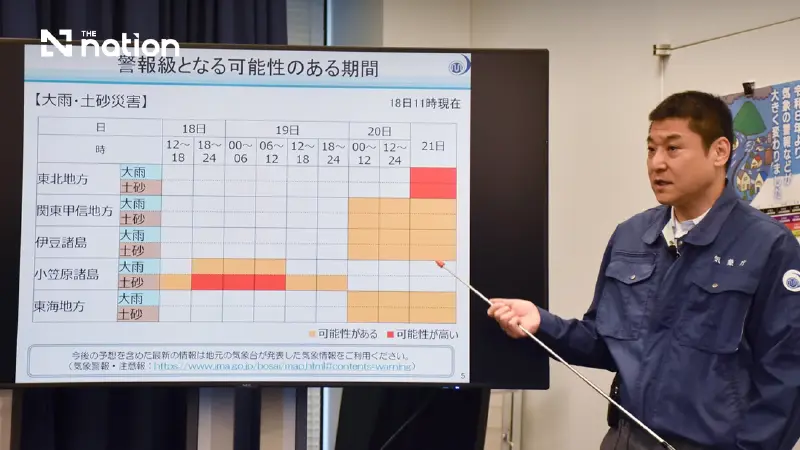


The Japan Meteorological Agency warns of landslides, flooding, transport disruption and high waves as rainfall could reach 300 millimetres in Tokai.
- Typhoon Dujuan is expected to cause travel disruptions in eastern Japan, particularly affecting public transport during a five-day holiday period.
- The storm is forecast to bring heavy rain, with up to 300mm in the Tokai region, creating risks of landslides and flooding.
- The Kanto region, including Tokyo, is expected to be approached by the typhoon on Monday, with warnings also issued for Tokai, Tohoku, and the Izu Islands.
- In addition to heavy rain, the Japan Meteorological Agency has warned of strong winds and high waves associated with the storm.
The Japan Meteorological Agency (JMA) warned that Typhoon Dujuan could disrupt public transport during the five-day holiday and bring heavy rain, landslides, flooding in low-lying areas, strong winds and high waves.
The storm is forecast to approach the Kanto region, including Tokyo, on Monday, while the agency has also urged vigilance in Tokai, the Pacific side of Tohoku and the Izu Islands.
JMA forecaster Yoshikazu Yano linked the warning to the holiday period, which runs through Wednesday.
“People who are planning leisure activities or returning to their hometowns during the holiday period should respond flexibly, including by changing their plans,” he said.
Yano said thick cloud north of the typhoon could produce rain before the storm drew closer, increasing cumulative totals.
Tokai could receive up to 300 millimetres in the 24 hours to 6pm on Monday, while Kanto, Tohoku and the Izu Islands could each receive 200 millimetres.
During the preceding 24 hours to 6pm on Sunday, rainfall could reach 200 millimetres in Kanto and the Izu Islands and 150 millimetres in Tokai.
Dujuan, the 25th typhoon of the year, was described as large when it neared the Ogasawara island chain on Friday afternoon.
At 3pm, its centre was about 170 kilometres south-southeast of Chichijima, moving west-northwest at 35 kilometres per hour.
The typhoon had a central pressure of 975 hectopascals, maximum sustained winds of 30 metres per second and peak gusts of 45 metres per second.
Winds of at least 25 metres per second covered a 110-kilometre radius, while winds of 15 metres per second or more extended up to 750 kilometres to the north-east and 390 kilometres to the south-west.
The forecast track takes Dujuan north before it begins moving away from Japan on Monday night towards waters east of Tohoku.
It is expected to become an extratropical cyclone by Tuesday afternoon.

[Copyright The Jiji Press, Ltd.]
