
Framework for Bangkok's development


Play
Sub-cities tipped to blossom in many areas
Bangkok has never stayed the same. And if a city plan can be a good indicator, the new face of the Thai capital is already taking shape.
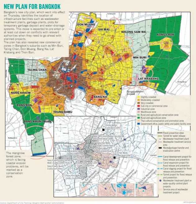
Bangkok’s latest city plan, which came into effect last Thursday, shows “sub-cities” set to mushroom across many suburban zones.
It has also identified the location of planned garbage plants and wastewater-treatment plants in a way that city officials believe will pre-empt lawsuits, protest and opposition from people who have chosen to live in those areas.
“With the identification, people will know what some empty fields will be turned into in the future. They should not complain later then if they decide to move into the zone,” the city planning chief at the Bangkok Metropolitan Administration (BMA) said.
Kriengphol Padhanarath said the new city plan was the fourth version for the capital.
“The city plan has provided framework for Bangkok’s development,” he said, noting its importance.
Bangkok got its first city plan in 1992, he said. During the past two decades, it has been adjusted three times to respond to changing needs and circumstances. And as Kriengphol has pointed out, it has a huge impact on people’s lives.
“So, we have not introduced drastic changes. We have been trying to find a balance for all stakeholders,” he said, reflecting the concept behind the latest plan. Kriengphol said this city plan, for example, offers incentives to real-estate developers to allocate areas for long-term residents around their project sites.
“They may develop flats and give some units to old residents. Or they may find a nearby plot for them. It must be within a 5km radius.”
He said property owners who include public open areas in their compounds would also enjoy some incentives because such spaces were useful to Bangkok. “Otherwise, the capital would be too crowded with large buildings,” he explained.
Kriengphol said to ease traffic jams, owners of buildings within a 500-metre-radius from rail-based systems’ stations would be awarded incentives if their number of parking lots was higher than legal requirements. This offer is based on an assumption more commuters will agree to leave their vehicles and ride a train. For flood prevention, building owners who prepare an area to retain at least one cubic metre of water will also enjoy incentives.
“There are motivations for green buildings as well,” Kriengphol said.
His deputy Panyapat Noppun said the latest city plan identified potential economic zones of the near future. “We are going to see commercial activity stretch down Kanchanaphisek Road,” he said.
Kriengphol said big buildings were also stretching along rail-based systems’ routes now.
Panyapat said Taling Chan, Min Buri, Wong Wian Yai and Chaeng Wattana would become sub cities very soon. “They will get the downtown atmosphere,” he said.
The MRT Orange and Pink Lines will meet in Min Buri, raising its chance of becoming a key sub-city. The current government has vowed to complete the construction of these lines by 2019. While sprawling urban growth is expected, Panyapat is convinced Bangkok residents will still have some green areas. “We aim to give six square metres of green areas to each Bangkok resident, up from just three to four square metres.”
The latest city plan recommends a green zone at Bang Khun Thieng because it has mangrove forest and is located by the seaside, he noted.
“We are going to discourage industrial and commercial activities there. There are coastal-erosion problems and risks of storm surges,” he said. Kriengphol, however, reckoned that Bangkok’s city plan had not been integrated with those for adjacent provinces.
“We have a designated floodway and banned construction along the floodway. But we can’t be sure what lies outside Bangkok,” he admitted.
