
Irrigation Dept offers two routes


Play
Canals will divert water and irrigate more than 70,000 rai
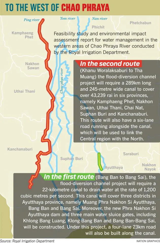
The Royal Irrigation Department (RID) yesterday came up with two potential routes the huge flood-diversion channels could take on the west bank of the Chao Phraya River.
Each route , covering 17 provinces in total, is expected to divert more than 1,200 cubic metres of water per second from the Ping River into the Gulf of Thailand, according to the feasibility study and environmental impact assessment report.
The report, based on a study conducted by three companies, including the Tara Consultant Co and Sigma Hydro Consultant Co, was revealed at a public forum held by the RID yesterday. At the event, department officials listened to Nakhon Pathom residents’ opinions about the water-management project.
The event was attended by hundreds of people who expressed their concerns about the social and environmental impact from the project. They also voiced worries about land expropriation and compensation.
The three companies have been conducting surveys to estimate economic, social and environmental impacts as well as the engineering implications since last August 30, and are expected to complete the report by October 23.
According to the study so far, the first option will be to build a 22-kilometre canal to drain water at the speed of 1,200 cubic metres per second. This canal will cover three districts in Ayutthaya, namely Muang Phra Nakhon Si Ayutthaya, Bang Ban and Bang Sai.
In addition to this, a new dam called Phra Nakhon Si Ayutthaya along with three main sluice gates including Klong Bang Luang, Klong Bang Ban and Bang Ban-Bang Sai would be constructed.
Under this project, a 23km four-lane road would also be built along the canal.
Under the second option, a 289km-long, 245-metre-wide canal will be built to cover more than 43,239 rai (6,918 hectares) in six provinces, namely Kamphaeng Phet, Nakhon Sawan, Uthai Thani, Chai Nat, Suphan Buri and Kanchanaburi.
This route would also have a six-lane road alongside the canal, which will be used to link the Central region with the North.
This canal is expected to drain 1,200 cubic metres of water per second from the Ping River to the Gulf of Thailand. The canal will start in Kamphaeng Phet’s Khanu Woralaksaburi district and will end in the upper area of the Mae Klong dam in Kanchanaburi’s Tha Muang district.
ACCESS TO WATER-
The project will help irrigate 618,231 rai of farmland during the rainy season and 71,322 rai in the dry season.
“Constructing a new flood-diversion channel on the west of the Chao Phraya River will be useful for areas that have been facing water shortages over the past decades,” said the project’s assistant manager, Associate Professor Weeraphon Taesombat.
The project’s secretary Arthon Suthikarn said this scheme was not related to the flood-diversion channel or module A5 under the government’s Bt350-billion water- and flood-management project because the RID been conducting its study well before the government’s mega-project came up.
However, whether this study manifests into a proper project depends very much on the government, he said.
