
RID warns 8 provinces as river levels rise on September 28
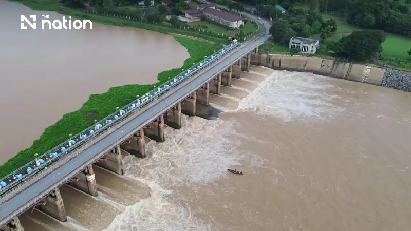


Mae Klong River could rise by about 2.50 metres downstream as officials prepare for releases above 1,500 cubic metres per second
The Royal Irrigation Department (RID) has warned residents in eight provinces in central and western Thailand to prepare for rising water as heavy rain increases flows in the Chao Phraya and Mae Klong basins. The warnings include a Chao Phraya notice issued on September 28, 2026, urging vulnerable communities upstream of the dam to move belongings to higher ground.
The RID plans to temporarily retain water above Chao Phraya Dam to ease pressure on flooded areas downstream. In the Mae Klong basin, rising inflows could require releases exceeding 1,500 cubic metres per second, potentially raising downstream river levels by about 2.50 metres.
Chao Phraya retention puts three upstream provinces on alert
The RID’s Chao Phraya warning, Notice No. 2 dated September 28, identifies three provinces where communities upstream of the dam should prepare for higher water levels:
1. Nakhon Sawan
2. Uthai Thani
3. Chai Nat
The RID said persistent heavy rain and accumulated rainfall in the upper North were sending increasing volumes of runoff into the Chao Phraya River. Its September 28 assessment set out the following readings and forecasts:
- Measured flow at station C.2: Water was passing the monitoring station in Mueang district, Nakhon Sawan, at 1,904 cubic metres per second at 6am on September 28, 2026.
- Forecast flow at C.2: The rate was expected to rise to approximately 2,000–2,200 cubic metres per second.
- Forecast flow at Chao Phraya Dam: Including additional inflows from tributaries, the volume passing the dam was expected to reach 2,200–2,400 cubic metres per second.

The RID said flooding persisted in several areas along the lower Chao Phraya, while riverside communities outside flood embankments were already being affected by overflowing water. Temporarily holding runoff in available areas upstream of the dam would reduce peak flows and limit the additional water reaching those communities.
The RID acknowledged that retaining water above Chao Phraya Dam would raise upstream levels, but said officials would manage the water so that it did not exceed 18.00 metres above mean sea level.
The RID urged residents in vulnerable upstream areas, along with operators of riverbank protection works, floating restaurants and fish cages, to move property to higher ground, take protective measures and closely follow official water-level warnings.
Mae Klong releases could raise downstream water by 2.50 metres
Regional Irrigation Office 13 warned that increasing releases through Mae Klong Dam to more than 1,500 cubic metres per second could raise the river downstream by approximately 2.50 metres above the level at the time of the warning. The office issued its alert after flows in both the Khwae Noi and Khwae Yai rivers rose rapidly.
Regional Irrigation Office 13 reported the following conditions:
- Khwae Noi River: Telemetry station K.58 at Ban Pak Saeng, Sai Yok district, Kanchanaburi, recorded a flow of 1,441 cubic metres per second at 6pm on September 27, 2026, with the volume continuing to rise.
- Khwae Yai River: Water volumes were already high and were increasing further.
- Combined inflows: Large volumes from the two rivers were converging and entering the Mae Klong River rapidly.
The RID sent its warning for communities below Mae Klong Dam to provincial governors and relevant agencies, covering five provinces:
1. Kanchanaburi
2. Ratchaburi
3. Nakhon Pathom
4. Samut Songkhram
5. Samut Sakhon
The RID urged residents along the Mae Klong River, in low-lying riverside areas and near tributaries to prepare for a rapid increase in water levels. Residents were advised to move belongings to higher ground and relocate pets and vehicles to safe areas.
Agencies coordinate continuous monitoring and local warnings
The RID is working with provincial governors, government agencies, local authorities and disaster prevention and mitigation officials to monitor conditions and reduce flood impacts across the Chao Phraya and Mae Klong basins.
The coordinated measures include:
- Round-the-clock monitoring: Using telemetry and satellite data to assess rainfall and river flows, allowing discharge plans to be adjusted as conditions change.
- Local warnings: Sending alerts to community leaders and village warning towers so information reaches people in vulnerable areas quickly.
- Drainage equipment: Installing pumps and water-propulsion machines at locations prone to standing water to accelerate drainage towards the Gulf of Thailand.
- - Water retention: Holding water in designated receiving areas and managing flows to balance the effects on communities upstream and downstream of the dams.
The RID urged residents in the eight affected provinces to remain calm but vigilant, monitor weather conditions and follow water warnings through official government channels and the department’s Facebook page.
