
Thailand reservoirs near full as levels at 32 river stations rise above banks
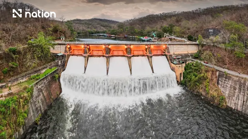


Thailand’s reservoir pressure is rising, with Pa Sak Jolasid at 102% and Prasae at 115% of capacity as 32 river stations in 15 provinces exceed their banks.
- Heavy rainfall has left Thailand's major reservoirs nearly full, with 13 large reservoirs assessed holding a combined 94% of their total capacity.
- Water levels have risen above the banks at 32 monitoring stations across 15 provinces, prompting flood concerns in several regions.
- Several individual reservoirs are over capacity, including the Prasae Dam at 115% and the Pa Sak Jolasid Dam at 102%.
- In response, authorities have increased the water discharge from the Chao Phraya Dam, which is expected to raise downstream river levels further.
Thailand’s water situation has become increasingly strained towards the end of September, as heavy rainfall in the Ping River basin sent the flow at station P.7A in Kamphaeng Phet surging from 700 to 1,700 cubic metres per second.
Combined with water from the Sakae Krang basin, the additional flow has moved into the Chao Phraya River faster than expected.
The Office of the National Water Resources (ONWR) issued Notice No. 7/2026 on Wednesday (September 30), calling for discharge through Chao Phraya Dam to be increased to 2,200 cubic metres per second. The adjustment is expected to raise downstream water levels by another 20–30 centimetres.
Meanwhile, the Royal Irrigation Department (RID) reported that all 13 large reservoirs covered by its latest assessment were holding more than 80% of their capacity, with none at or below 30%.
Together, the reservoirs have a combined capacity of about 32.092 billion cubic metres and currently hold 30.190 billion cubic metres, or around 94%, leaving about 1.9 billion cubic metres of net available storage.
Hydrological data recorded at 6am on Wednesday showed water above bank level at 32 monitoring stations across 15 provinces. Levels were falling at 17 stations but continuing to rise at 15.

Chao Phraya Dam discharge increased
Water passing station C.2 in Mueang Nakhon Sawan district was flowing at between 1,800 and 2,350 cubic metres per second.
Authorities have been using areas upstream of Chao Phraya Dam to slow the flow while diverting water into irrigation canals on both the western and eastern sides at full capacity, totalling about 500 cubic metres per second.
However, additional water from the Ping and Sakae Krang basins has increased flows across both the upper and lower sections of the basin. ONWR indicated that higher discharge was necessary to manage the rising volume and reduce potential damage.
Six provinces require close monitoring: Chai Nat, particularly Sapphaya district; Sing Buri, including Phrom Buri, Mueang Sing Buri and In Buri; Ang Thong, covering Mueang Ang Thong, Chaiyo, Pa Mok and Wiset Chai Chan; and Ayutthaya, including Bang Sai, Sena, Phak Hai, Bang Ban, Phra Nakhon Si Ayutthaya, Bang Pa-in, Lat Bua Luang and Bang Sai districts.
Sam Khok and Mueang Pathum Thani districts in Pathum Thani, as well as Mueang Nonthaburi, Bang Kruai and Pak Kret districts in Nonthaburi, are also being monitored.
Northern reservoirs above 90%
Mae Ngat Somboon Chon Dam in Chiang Mai held 246 million cubic metres of water against its 265-million-cubic-metre capacity, or 93%. Usable storage stood at 233 million cubic metres.
Daily inflow was 0.84 million cubic metres, down from 1.09 million the previous day, while 0.51 million cubic metres was released. The reservoir had another 19 million cubic metres of available storage.
Kiu Lom Dam in Lampang contained 96 million cubic metres against a capacity of 106 million, or 91%. Inflow increased to 2.31 million cubic metres from 1.87 million the previous day, while 2.07 million cubic metres was released. Remaining storage capacity stood at 10 million cubic metres.
Kiu Kho Ma Dam, also in Lampang, held 161 million cubic metres against its 170-million-cubic-metre capacity, or 95%. Inflow eased to 1.06 million cubic metres from 1.20 million, while releases remained unchanged at 0.39 million cubic metres. The reservoir could take another 9 million cubic metres.
Northeast reservoir at 91%
Sirindhorn Dam in Ubon Ratchathani held 1.798 billion cubic metres against a capacity of 1.966 billion, or 91%.
Usable storage was 967 million cubic metres, or 85%. Inflow fell sharply to 6.72 million cubic metres from 11.59 million the previous day, while releases declined to 8.63 million cubic metres from 10.77 million.
The reservoir had 168 million cubic metres of remaining storage capacity.

Pa Sak Jolasid exceeds capacity
Pa Sak Jolasid Dam in Lopburi contained 891 million cubic metres against its stated capacity of 872 million, putting storage at 102%.
Usable storage stood at 877 million cubic metres. Daily inflow reached 52.95 million cubic metres, down from 63.74 million the previous day, while releases were almost unchanged at 2.16 million cubic metres compared with 2.17 million.
The figures put available storage at minus 19 million cubic metres.
Kanchanaburi dams receive heavy inflows
Srinagarind Dam in Kanchanaburi, the largest of the 13 reservoirs, held 16.374 billion cubic metres against its 17.745-billion-cubic-metre capacity, or 92%.
Usable storage stood at 6.109 billion cubic metres. Inflow climbed to 240.93 million cubic metres from 194.06 million the previous day, while releases fell to 2.01 million cubic metres from 3.94 million.
The reservoir still had 1.371 billion cubic metres of available storage, the largest remaining capacity among the 13 reservoirs.
Vajiralongkorn Dam, also in Kanchanaburi, held 8.534 billion cubic metres against a capacity of 8.860 billion, or 96%, with usable storage of 5.522 billion cubic metres.
Its daily inflow jumped to 287.63 million cubic metres from 108.84 million the previous day, the highest inflow among the reservoirs covered by the report. No water was released on either day, leaving 326 million cubic metres of available storage.
Kaeng Krachan Dam in Phetchaburi held 701 million cubic metres against its 710-million-cubic-metre capacity, or 99%.
Usable storage stood at 636 million cubic metres. Inflow reached 39.39 million cubic metres, little changed from the previous day, while releases remained at 8.64 million cubic metres. Only 9 million cubic metres of storage remained available.

Prasae reaches 115% as Khlong Si Yat fills
Khlong Si Yat Dam in Chachoengsao was at its full 420-million-cubic-metre capacity.
Daily inflow stood at 48.54 million cubic metres, down from 50.44 million the previous day, while releases increased sharply to 43.41 million cubic metres from 24.82 million. No additional storage capacity remained.
Prasae Dam in Rayong recorded the highest percentage of capacity among the 13 reservoirs, holding 338 million cubic metres against its stated capacity of 295 million, or 115%.
Inflow increased to 33.19 million cubic metres from 27.50 million, while releases rose to 33.20 million cubic metres from 27.94 million. Available storage was reported at minus 43 million cubic metres, the largest negative figure in the table.
Nong Pla Lai Dam in Rayong held 144 million cubic metres against a capacity of 164 million, or 88%, the lowest percentage among the 13 reservoirs.
Inflow declined to 10.05 million cubic metres from 14.88 million, with releases at 0.43 million cubic metres. The reservoir had 20 million cubic metres of remaining storage.
Khun Dan Prakan Chon Dam in Nakhon Nayok contained 217 million cubic metres against a 224-million-cubic-metre capacity, or 97%.
Inflow dropped to 11.48 million cubic metres from 14.29 million, while releases fell to 13.41 million cubic metres from 19.43 million. Remaining storage stood at 7 million cubic metres.
Naruebodindrachinta Dam in Prachin Buri held 270 million cubic metres against its 295-million-cubic-metre capacity, or 92%.
Inflow eased to 5.47 million cubic metres from 8.23 million. No water was released on either day, leaving another 25 million cubic metres of available storage.

River levels above banks across 15 provinces
In the North, station P.78 at Khlong Khlung in Kamphaeng Phet was 0.18 metres above bank level and falling.
In Phetchabun, station S.42 in Wichian Buri was 0.50 metres above its bank and S.52 in Si Thep was 0.43 metres above, with both levels falling.
In Phitsanulok, stations Y.16 and Y.64 in Bang Rakam were 0.07 and 0.05 metres above bank level respectively, with both continuing to rise.
In the Northeast, station E.85 on Nam Choen in Chum Phae district, Khon Kaen, was 0.07 metres above its bank, while station M.26A on Lam Chi in Krasang district, Buri Ram, was 1.37 metres above. Both were rising.
Ayutthaya stations continue to rise
Ayutthaya was among the areas of greatest concern, with all stations detailed in the report showing rising water levels.
Station C.67 on the Noi River in Sena was 2.31 metres above bank level, while C.36 on Bang Luang Canal in Bang Ban was 1.79 metres above.
Station C.68 in Sena was 0.82 metres above its bank, C.35 on the Chao Phraya River was 0.57 metres above bank level, with water flowing at 1,321 cubic metres per second, and C.37 in Bang Ban was 0.03 metres above. All were rising.
Elsewhere in the Central region, station Ct.4 on the Mae Wong in Lat Yao district, Nakhon Sawan, was 0.80 metres above its bank, while Ct.8A in Thap Than district, Uthai Thani, was 0.15 metres above. Both were falling.
In the Tha Chin basin, Suphan Buri stations T.10 in Mueang district and T.13 in Song Phi Nong were 2.34 and 0.94 metres above bank level respectively, with both continuing to rise.
In Nakhon Pathom, station T.15 in Bang Len stood 0.80 metres above its bank and was rising, while T.1 in Nakhon Chai Si was 0.71 metres above and falling.
Kanchanaburi records highest overbank level
In the West, Kanchanaburi recorded the highest overbank reading included in the report.
Station K.58 on the Khwae Noi River in Sai Yok was 6.47 metres above bank level, while K.10 in Sai Yok was 4.84 metres above. Both were falling.
Station K.11A on the Mae Klong River in Tha Muang was 2.58 metres above its bank and continuing to rise.
The Lam Taphen station and K.12 in Mueang district were reported at around 0.5–1 metre above bank level.
In Ratchaburi, station K.55A on the Mae Klong River in Ban Pong was 1.07 metres above its bank, with water flowing at 1,969.01 cubic metres per second. The level was rising.
Eastern river levels mostly falling
In Sa Kaeo, station Kgt.12A on Khlong Phra Prong in Mueang district was 3.35 metres above bank level, while Kgt.9 in Khao Chakan was 0.44 metres above.
In Prachin Buri, station Kgt.6 in Si Maha Phot was 1.46 metres above its bank, while Kgt.13A and Kgt.43A in Kabin Buri were reported at 1.34 metres above bank level.
Station Z.11 on Khlong Prasae in Klaeng district, Rayong, was 0.38 metres above its bank.
All the eastern stations detailed in the report were showing a downward trend.
