
Typhoon Dolphin may intensify rain while bypassing Thailand
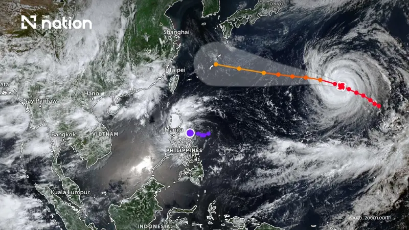


Typhoon Dolphin is forecast to bypass Thailand but may strengthen the south-westerly monsoon, bringing heavy to very heavy rain to the North and upper Northeast from August 7 to 9.
- Typhoon Dolphin is not forecast to enter Thailand and is expected to remain far from the country.
- The typhoon will indirectly strengthen the south-westerly monsoon, causing heavy to very heavy rain from August 7 to 9.
- Increased rainfall is expected to primarily affect the North and upper Northeast regions of the country.
- Officials have warned residents in vulnerable areas to be alert for potential flash floods and overflowing rivers.
Typhoon Dolphin is not forecast to enter Thailand directly, although its indirect influence could bring heavy to very heavy rain to parts of the country, particularly the North and upper Northeast, from August 7 to 9.
The Thai Meteorological Department (TMD) issued the clarification after information about Typhoon Dolphin circulated online. The storm remains far from Thailand in the Pacific Ocean and is expected to move towards Japan and the Chinese coast rather than towards the kingdom.
However, the typhoon could indirectly strengthen the south-westerly monsoon prevailing over Thailand between August 7 and 9. Rainfall may increase in several areas, with heavy to very heavy downpours possible, particularly in the North and upper Northeast.
People in vulnerable areas have been advised to remain alert for flash floods, forest run-off and rivers overflowing their banks, the department stated.
Depression near the Philippines expected to weaken before reaching Thailand
A separate tropical depression east of the Philippines may briefly strengthen into a tropical storm.
However, weather models used by the TMD indicate that the system could be absorbed into Typhoon Dolphin’s circulation before weakening. It is therefore not currently expected to affect Thailand directly, according to the department.

Thailand’s rain driven by monsoon, not Typhoon Dolphin
The TMD stressed that Thailand’s current rainfall is mainly being caused by the monsoon trough and south-westerly monsoon, rather than by Typhoon Dolphin entering the country, as suggested in posts shared on social media.
The department urged the public not to panic over rumours, noting that the latest information showed no indication that the typhoon would change course towards Thailand.
People should follow official weather forecasts and announcements from the TMD for accurate and timely information, it added.
